My Corner Online
Hickory Canyons Natural Area
March 30, 2018
We visited Hickory Canyons after it had rained two days. I had understood timing was key to catch the falls at their best flow and I was pleased with our timing. The falls were beautiful! This place is not far from the more popular Pickle Springs near Farmington, Missouri. We took Highway 55 to Highway 32 towards Farmington to Highway C. Go north about three miles on Highway C and turn left (south) on to Sprott Road (gravel) for about 1.75 miles to the parking lot. Our GPS did a nice work in finding the place for us.
Please enjoy the above video of many of my photos and short videos snippets as we hiked.
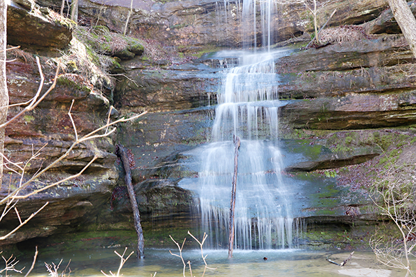
This waterfall is the beginning of Establishment Creek. I followed it on Google maps and it appears to go a great distance until flowing into Lake Ocie which flows into Lake Wanda Lee, then continuing under Highway 55 just south of Bloomsdale, and then into the Mississippi River at Magnolia Hollow Conversation Area. The name of the creek comes from an early settlement in the 1790's.
Hickory Canyons are the "largest known sandstone canyons in the State of Missouri." Nearby are many sandstone canyons in the
Shawnee National Forest of Illinois.
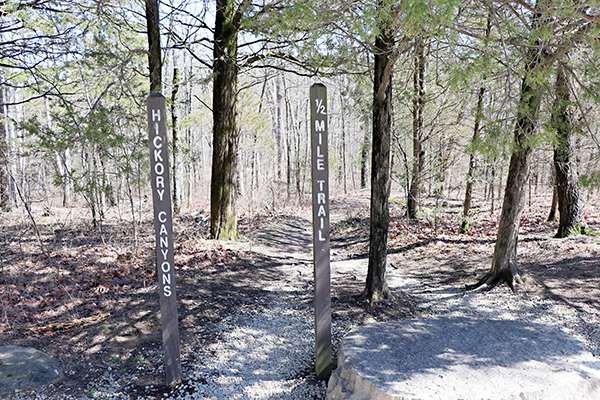
The trail on the same side as the parking lot led down to the big fall. It was a 1/2 mile trial, so a short hike, but the trail was rocky and rough. Having rained it was also wet in areas and we walked along the edge of the trail instead making it more difficult. 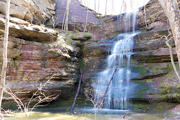
It was worth it though! The sign said the trail was a 1/2 mile there and back. However, rather than turning around after viewing the falls as we saw some doing, we were adventurers and followed the example of a few who crossed the small stream on the log and followed the trail as it continued around the edge of the bluffs. We were delighted to have discovered another fall on the other side! However, we were at the bottom of the bluffs and there seemed a few options for going up, but none of them were easy for this old overweight me. I braved it and climbed straight up the rocks to the top. It was not too difficult, but it was certainly dangerous and I do not recommend being stupid like me. Once at the time the trail did continue along the edge of the bluffs, but I felt that at any moment I could loose my balance and fall off the edge of the cliff. It would have taken only one slight off-balance and was rather dangerous. I was thankful when the bluff was not so close to the edge and we delighted in seeing the big falls from overhead. We crossed the creek that fed the fall and traveled back to the parking lot.
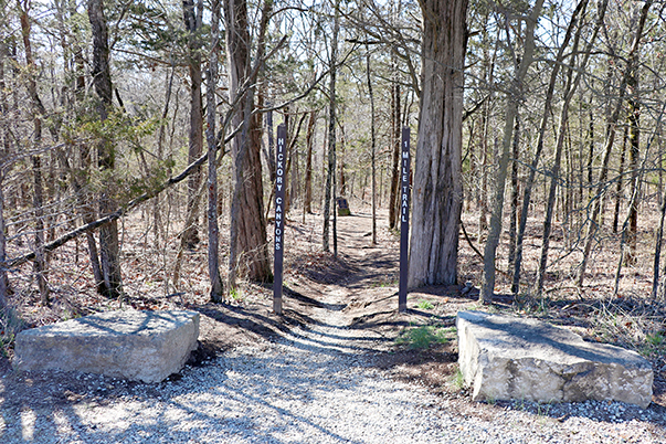
Across from the parking lot is the other trail. I debated skipping it because I had already hiked at Falls Branch Falls and Ball Mill Resurgence Natural Area in Perry County earlier in the day. I have bad feet and can only walk so far and had already reached my limit. I could not resist taking the trail having already traveled this far. We had met a couple on the first trail that said the second trail was easier. Goodness, was that wrong! We figured out after some hiking that they must have made a left turn at the fork and gone straight to the wooden stairs and second falls and back to the top. Yes, that was an easier hike. However, we went right at the fork and did the whole 1 mile trail. I must say that it felt much longer than 1 mile. The terrain was so rough that it was a slow-going for me. The first quarter or more of the trail was straight down and I do not do well with walking down as well as I do walking up. I held onto hubby's shoulder a lot for stability. We thought we would never make it. It just kept going down and down and down some more. At some points the trail was the stream and we wondered if we were on the trail, but then we would see an obvious trail up ahead and realize we were okay and on the path. When we finally made it to the bottom I said I had to take a photo to document it because I was never doing this trail again.
The next section of the trail was really nice. It was flat and followed the larger creek. However, hubby had worn tennis shoes and had to give up all hope of keeping them dry as this wider creek was crossed many times while meandering along the bottom of the canyon. It was a beautiful walk and we enjoyed the bottom of the canyons.

Then we came to the part on the map that had a warning of "steep bluffs." It had hubby a little concerned. It certainly did look intimidating! For as long as we had walked downhill, we were ready to go straight up. However, I found this part of the trail rather easy. I go up better than I go down. The trail did curve up the bluff making it a bit more gentle. We arrived at the man-made steps and found the waterfall feature for this trail. It was not as exciting as the big falls across the road. The rest of the trail back to the beginning was not too bad, but I had had enough for the day and kept yearning for that sight of my car so I could get off my feet.
If I were younger, I wouldn't hesitate to do this trail again. It is really awesome. However, I took lots of videos along the way to remember the trail because I doubt I will ever do it again. I think it was the roughest trail I have ever been on. I will come back and do the trail on the side of the parking lot again though. Regardless, I was glad to have had this experience while I am still able.